
Mishima Pond (三島池)
Flow of the course
About 30 min from the previous stop
About 45 min here
About 15 min to the next stop
Next stop: Stroll through an English-style garden and enjoy lunch at the on-site restaurantAbout this spot
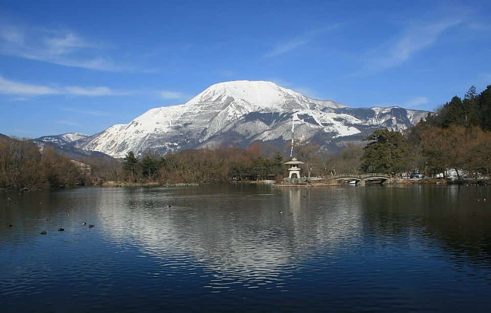
A reservoir spanning approximately 780m in circumference at the southwestern foot of Ibuki Mountain, with a long history supporting agricultural water. On calm days, the image of Ibuki Mountain reflects clearly on the water's surface, earning it fame as a scenic photography spot known as the "Inverted Ibuki." Many waterfowl, including mallards, gather here, and the pond is designated as a Shiga Prefecture Natural Monument as a natural breeding ground for mallards. A flat hiking trail circles the pond, making it safe and comfortable for strollers with babies, grandparents with unsteady legs, or anyone to leisurely walk the entire loop. Enjoy four seasons of beauty throughout the year—spring cherries, summer's deep green, and autumn foliage—with Ibuki Mountain as a borrowed landscape, making it a cherished recreational spot for locals.
Tips
It's about a 10-minute drive from Yonehara IC on the Hokuriku Expressway; a free parking lot is available near the pond. Even a full circuit of the pond takes only about 15 minutes on flat, stroller-friendly terrain. For the best chance of seeing the mirror-image Ibuki, early morning with calm winds is ideal. Bring your own drinks as there are few vending machines or shops nearby.
Best time to visit
Approximately 45 minutes. Early morning when winds are calm and the mirror-image reflection of Ibuki is most likely to appear is the best time
How was this spot?
現地の天気
28°C(現在)直近1週間の寒暖差は平均5℃。気温差が大きい日が続くと紅葉が進みやすいと言われています。
Weather data by Open-Meteo.com
Access & map
〒521-0221 Yonehara, Shiga Prefecture, Ikedemoshita, Mishima Pond (〒521-0221 滋賀県米原市池下 三島池)
Model course featuring this spot

Yonehara: Scenic Drive on Ibuki Mountain and the Clear Streams of Samegai-shuku
Shiga
Other courses featuring this place
2026年 米原市伊吹B&G海洋センタープール 1日満喫コース
伊吹山を映す静かな池と鴨の姿
Explore features & model courses










Like this spot? Sign up free to save it to your own booklet as a plan or a want-to-go.